By Sophie Clayton, National Oceanography Centre
Predicting how the carbon cycle will respond to a warming climate is still an open question, with CMIP6 climate projections giving a wide range of projections for how ocean biology will interact with higher temperatures and higher atmospheric carbon dioxide. To improve these projections, we need to gain a clearer understanding of the current day ocean carbon cycle. Unfortunately, observing all of the elements of the carbon cycle simultaneously isn’t possible with our current technology, so our best bet for trying to piece together how carbon moves between the atmosphere, different layers of the ocean and eventually the sediments, is to bring together observations made using different platforms and instruments in different places. Part of my job as a research scientist working on understanding how biological processes in the surface ocean control the flux of carbon to deeper ocean layers, is to pull these different types of data together to build a picture of how the system works and what elements are most important in controlling it.
The ecosystem in the surface ocean plays an important role in fixing carbon dioxide from the atmosphere and converting it to particulate organic carbon. This part of the process is done by phytoplankton, microscopic plants that live in the sunlight surface layers of the ocean (although we are now discovering how important whales can be too, read the blog here). Phytoplankton are a massively biodiverse group of organisms, whose cell sizes range over at least 5 orders of magnitude… that’s like the size difference between a mouse and an elephant!

We believe that the size range of the phytoplankton is an important control on the amount of carbon that makes it to the deep ocean, and so I am developing ways of getting estimates of carbon export from the size structure of the phytoplankton in the surface.
Unfortunately, it is incredibly rare to find a dataset where the surface phytoplankton size distribution and deep ocean carbon flux were measured at the same time! Thankfully, I can pull together a range of data from different sources to start to build a picture of what is going on.
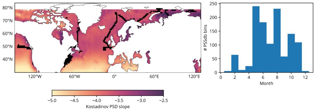
Imaging instruments can capture millions of images of phytoplankton cells during a research cruise or a deployment on a mooring, and thanks to these data we are now starting to build a detailed view of how the size structure of phytoplankton varies regionally and seasonally. Colleagues in the US and the EU have curated a compilation of these size structured data that is now freely available and I have been diving in and using this in my analyses. Along with these direct measurements, there are satellite products that give global estimates of the phytoplankton size structure from space, these are less accurate than the direct observations made from collecting samples or images in situ, but they give a broad picture, with many fewer gaps, that we can’t get from direct observations. Estimating how much and how quickly carbon sinks out of the surface into the deep ocean is an even harder quantity to estimate than the surface phytoplankton size structure since we can’t “see” this process with a satellite. However, autonomous robots equipped with optical sensors and set to drift on the ocean for years at a time provide us with the data needed to estimate carbon flux down to at least 1,000 m .I’m still in the early stages of my analyses, but with enough overlap in these different data products collected from space, the surface and the deep ocean, I am starting to see clear links between the surface ocean phytoplankton community structure and deep ocean carbon export that are feeding into the next stage of the research: developing proxies for carbon export that can be determined from space. These new insights are going to help us improve how we model and predict the biological carbon pump, driving new insights into how carbon will be cycled through the climate system in future oceans.

Dr. Sophie Clayton
Work Package: WP 4
Organisation: National Oceanographic Centre